Alan & Sandra’s Incredible Cross Country Adventure
Mexico City + Hidalgo Provence + Tepoztlán
Malinalco + Taxco + Puebla + Oaxaca
Trip Overview – This adventure took us to Mexico City and areas east and south of the city. Some people were surprised that we would consider traveling to Mexico in the Summer and that it would be too hot. This was not the case for us because, 1) Our entire trip was over 5,000 feet (1,500 meters), and 2) the hottest season for this region is Spring. June is the start of the rainy season which cools things down. It rained almost every day of our trip, but this was only a minor inconvenience. It did not rain once before 2:00 pm and often would not start until much later in the evening. Most of the mornings and early afternoons were bright and sunny.
Mexico City (CDMX)
Overview – Founded in 1325, CDMX is one of the oldest cities in North America. CDMX is a city of contrasts blending ancient Aztec roots and colonial influences in a vibrant, modern, cosmopolitan city. Here you can see traditional handicrafts displayed next to cutting edge art, and traditional street food vendors near world-class restaurants. Renowned for its vibrant arts, and culture, world class museums, trendy neighborhoods, amazing architecture, and endless culinary options, CDMX can keep a visitor occupied for weeks without running out of things to see and do.
Demographics – CDMX has a metro population of 21.6MM making it the fifth largest urban area in the world. 60% of city’s residents are of mixed indigenous and European decent, 20% are of European decent and 15% are indigenous. CDMX is also home to an estimated 20,000 American citizens.
Getting Around – Getting around town is super easy. With 12 rail lines covering 141 miles (227 km), the CDMX metro system is the second largest in the western hemisphere. In addition, there are seven dedicated rapid bus lines with stops that resemble train stations, three cable car lines, and numerous local bus lines. A single ride costs just $0.27. For areas not easily reached by public transit, there is Uber. A typical half hour ride costs around $9. Much of the city is pedestrian and bicycle friendly. CDMX has 248 miles (400 km) of dedicated trails and 444 bicycle rental stations. Every Sunday 30 miles (50 km) of downtown roadways are closed and become accessible to pedestrians and cyclists.
Elevation – At 7,300 feet (2,200 meters), CDMX is one of the highest metro area in the world.

Heading 6


Heading 6


Heading 6
Heading 6


Heading 6


Tenochtitlan Archaeological Zone – Built in the early 1300s, Tenochtitlan was the temple complex of the former Aztec capital. Little remains today of these structures, because the Spanish took apart these temples brick by brick to build their cathedral. Though the ruins might be a little bit of a letdown compared to other archaeological sites, being that it is located right in the middle of the Centro district it provides a striking dialog between yesterday and today. Also, the museum sitting in the middle of the complex is very good and worth seeing.


Heading 6
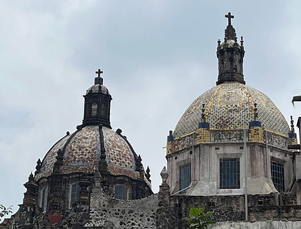
Catedral Metropolitana – This massive tilting church was built in sections from 1573 to 1813 making it one of the oldest cathedrals in the western hemisphere. The structure is tilting because it has sunk 23 feet since being completed. The long construction time led to the use of numerous architectural styles from gothic to neoclassical.


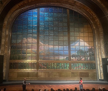
Palace of Fine Arts (Palacio de Bellas Artes) – This beautiful art nouveau on the outside and art deco on the inside building is the city’s main venue for the performing arts. The center piece of the auditorium is the stained-glass curtain assembled by New York jeweler Tiffany & Co from almost a million pieces of colored glass. Free tours of the auditorium are offered in English Wednesdays to Fridays at 1:00. For a small entrance fee, you can also visit the mural museum on the second floor that houses some of the country’s best examples of this art form from artists such as Diego Rivers, Jose Clemente Orozco and David Alfaro Siqueiros


National Museum of Anthropology – There are plenty of good museums exhibiting artifacts from Mexico’s pre-Columbian period scattered throughout the country, but this one is by far the best and should not be missed. With 600,000 objects on display, it is the largest and most visited museum in the country. Most of the larger pieces are replicas that were made so perfectly you can’t imagine them not being originals. Much of the labeling is only in Spanish, so it is recommended to participate in a guided tour to truly appreciate what the museum has to offer.


Heading 6


Heading 6


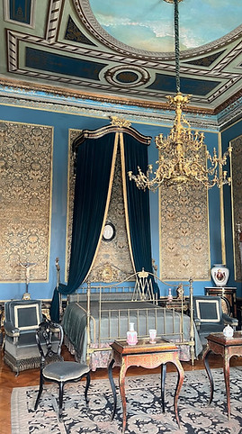
Chapultepec Castle (Castillo de Chapultepec) – Built in the late 1700s atop a 300-foot-tall (90 meter) hill, Chapultepec Castle became the home of Emperor Maximilian who filled its rooms with sumptuous furnishings from Europe. Later the castle became the presidential residence until 1939 when it was converted into a museum. From its several balconies, the castle offers some of the best views of the city.


Heading 6


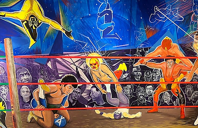
Lucha Libre – No visit to Mexico would be complete without witnessing one of these uniquely Mexican theatrical/acrobatic wrestling matches. A typical evening event would include five matches of two teams of masked wrestlers (luchadores). The event we witnessed also included one match of female luchadoras. These events are quite exciting to watch with their gravity defying acrobatic maneuvers and complex holds. But these matches are more than just a show of athleticism. They also feature a classic good-versus-evil narrative. The good guys would fight honorably while the bad guys would use cheating tactics. The audience loved this narrative and would loudly cheer on the good guys and boo the bad guys.


Heading 6


Heading 6


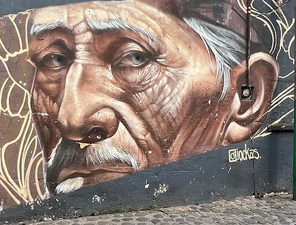
Murals – México has a strong history of mural art. Many of these murals highlight aspects of Mexican culture, or express political statements. You can find these works of art on the sides of humble homes and shops as well as stately office buildings. It’s estimated that there are as many as 9,000 murals in the city. We absolutely love this art form and would often walk a block out of our way just to get a glimpse of a new mural.


Heading 6


Heading 6


Cable Cars – The best and most fun way to see CDMX is from inside a ten-seater cable car suspended a hundred feet (30 meters) above the ground. This cable car system was built to be used as public transit and not as a tourist attraction. So, none of the three cable car routes go to any tourist sites. We took the ride to see the city from a different point of view.


Teotihuacán Archaeological Zone
Overview – With an estimated population of 250,000, Teotihuacán was probably the largest city in the pre-Columbian Americas. The city flourished for 800 years until it was abandoned in the 700s. Teotihuacán is a massive complex covering eleven square miles. Its four most significant sights (see below) sit along the 1.5-mile-long Avenue of the Dead that runs the entire length of the city. It took us nearly six hours to thoroughly explore the entire complex. We visited the site on a weekday during the off season, and it was still very crowded. I hate to imagine what Teotihuacán is like during the high season on a weekend.
Getting There – With a two-hour round trip bus ride from CDMX, Teotihuacan can easily be completed within a day trip.
Mexican Pyramids – In this blog you will find references to the numerous pyramids we visited. They are commonly referred to as pyramids, because this is what the Spanish colonizers called them. However, none of them are technically pyramids. Rather they are stepped structures, built in layers, gradually receding to a flat top where a temple would stand.
Elevation – 7,500 feet (2,300 meters)


Balloon Rides – Depending on the day, you could see as many as 70 hot air balloons floating over the complex. All the balloons depart just once a day at about 6:00 AM. The rides typically last 40 to 60 minutes, and cost $150 to $200 per person.


Pyramid of the Sun – Standing 215 feet (66 meters) tall, this pyramid is the highest structure in the complex. It is believed that it was built during the second and third centuries and was covered with lime plaster on which brilliantly colored murals were painted. Previously, tourists were allowed to climb to the top of the structure. This led to the deterioration of the structure. Now, as with most of Mexico’s pyramids, tourists can only look but not touch.


Pyramid of the Moon – This pyramid which is located at the northern end of the Avenue of the Dead is 145 feet (45 meters) tall. It is believed to have been built over a 350-year period and completed around 450. Visitors are still allowed to climb the very steep steps leading halfway up the structure. This is more than enough of an elevation gain to get great pictures of the buildings lining the Avenue of the Dead.


Temple of Feathered Serpent – This temple, which was built in the second and third centuries, stands within a large 38-acre (15-hectare) courtyard. This six-level pyramid is decorated with fabulous sculptures of feathered head serpents and snakelike creatures that represent the deity Quetzalcoatl. In the 4th century there was some sort of ideological shift, and a new structure was built right in front of the temple completely obscuring it from view. Now the only way to get a good look at the temple is to climb to the top of the newer structure. From this lookout you can see the Pyramid of the Sun to the right and the Pyramid off the Moon off in the distance to the Left.


Quetzalpapálotl Palace – This palace was an architectural masterpiece for its time with ornately carved pillars and fine murals. The structure was given its name by the archeologists after determining that carvings on the pillars to be of feathered butterflies, the symbol for Quetzalpapálotl. Inside you can see murals of jaguars playing seashell trumpets and green birds with water flowing from their beaks.


Hidalgo Provence Road Trip
Overview – Most of the sites we visited in this region are not accessible by public transportation, so we chose to rent a car at the CDMX airport for this portion of our adventure. During our visit, we used the town of Mineral del Monte (also called Real del Monte) as our base camp, which is a three hour drive from CDMX. This area is totally off the tourist radar. During the five days that we spent in the region, we did not come across a single non-Spanish speaking tourist.
Tula Archaeological Zone – From approximately 900 to 1150, Tula was the capital of the Toltec empire and home to 60,000 people. The highlight of a trip to Tula is seeing the well-preserved 15 feet (6 meter) tall statues of Toltec warriors. The Tula site is also home to two pyramids (only one you can hike up), the remnants of palaces and temples, a museum, and cacti garden. From CDMX, Tula is a 4.5-hour bus plus taxi ride round trip.

Heading 6

Heading 6


Mineral del Monte – Mineral del Monte (Population 14,000 - Elevation 8,900 ft) was established as a silver mining town. In the early 1800s the local mines imported 350 Cornish miners to increase their production. Most of these minors remained in the area marrying local women. This left an English influence that remains today. The town's steep streets are lined with buildings showing Cornish influences, and there are at least 30 pastes shops selling the popular British dish with a Mexican twist. The nearest bus service is in Pachuca, a 20-minute taxi ride away.


Huasca de Ocampo – Huasca (Population 18,000 - Elevation 6,900 ft) with its cobblestone streets, interesting architecture, artisan craft stores, picturesque river walks, and lively square is considered one of the most beautiful small towns in Mexico. In fact it was the first town in Mexico to be given the esteemed classification of “Magic Town” (Pueblo Mágico). There are now 177 Pueblos Mágicos. The nearest bus service is in Pachuca, a 50-minute taxi ride away.


Heading 6


Basaltic Prisms (Prismas Basalticos) – Located four miles from Huasca, the Basaltic Prisms is a canyon lined with hexagonal and pentagonal shaped columns of basalt rock. These columns measuring 90 to 160 feet (30 to 50 meters) heigh were formed 2.5 million years ago by the slow cooling and contracting of lava from a volcanic eruption.


Heading 6


Hacienda Santa Maria Regla – Located next door to the Basaltic Prisms, the hacienda is a beautiful complex built in the late 1700s. Home to a chapel, a pond, courtyards, gardens, secret passageways, two waterfalls, a restaurant and hotel, the hacienda is a popular wedding destination and a great place to just relax.


Heading 6
Heading 6


Mineral del Chico – Sitting next door to Chico National Park, Mineral del Chico (Population 9,000 - Elevation 9,800) is a place for outdoor enthusiasts. We hiked in the park for a couple of hours and were surprised how lush the vegetation was compared to other hikes we have done in Mexico. The nearest bus service is in Pachuca, a 50-minute taxi ride away.


Heading 6
Heading 6

Texcotzingo Archaeological Zone – In the 1400s Texcotzingo was used as a summer resort for the Aztec royalty featuring an elaborate network of baths and terraced gardens. The site sits on top of a 600 feet (180 meters) high hill at the end of a very rough trail. In the 1.5 hours we spent at the sight, we only saw one other person. From CDMX, Texcotzingo is a 3.5-hour bus plus taxi round trip. Unless you are passing nearby in a car, as we were, this site is probably not worth the long transit time.


Heading 6


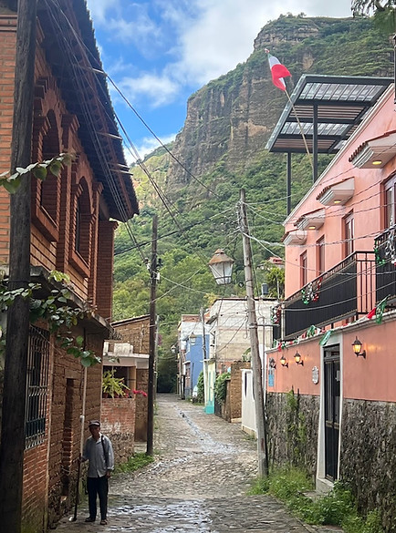
Tepoztlán
Overview – Tepoztlán’s colorful historical center is nestled in a valley surrounded by soaring jagged cliffs which can be seen from almost everywhere in the city. Because of its proximity to CDMX, Tepoztlán is a popular weekend destination that becomes quieter and more laid-back on the weekdays. The town attracts both outdoor enthusiasts and new age spiritualists. Tepoztlán is surrounded by twelve peaks, with the highest reaching 11,371 feet (3,646 meters). These mountains are believed to be the birthplace of the Aztec male god Quetzalcóatl and to be flowing with creative “male” energy making it a popular location for the practitioners of astrology, meditation, and yoga. Tepoztlán is also a great town for mural lovers.
Getting There – Frequent 1.5-hour express buses leave from CDMX’s Southern Bus Terminal.
Demographics – The city of 14,000 is also home to a couple hundred American citizens.
Elevation – 5,600 feet (1,700 meters)


Heading 6

Tepozteco Archaeological Zone – Built in the early 1500s, this 41 foot (12 meter) tall pyramid is located atop a sheer cliff at the end of a very steep path. Access to the trail is free, but to see the pyramid and viewpoint requires a small admission fee.


Tepozteco Trail (1.6 miles – 1,120 feet elevation) – The trail begins at the edge of town and continuously climbs up steeply until reaching the pyramid. The path was quite awesome, passing through tight canyons and past massive cliff walls. Much of the way was along stone steps. But a lot of the trail was over large round rocks that were challenging to navigate. We did the hike on a weekday, and it was still very crowded. Some locals we talked to claimed that they do this hike several times a week instead of going to a gym.


Heading 6


Malinalco
Overview – This historic town sits in a scenic river valley surrounded by ten peaks, with the tallest being 7,762 feet (2,366 meters) high. In Malinalco you can find adventure tour groups offering rappelling, zip-lining, and canyoning excursions. Malinalco is another town that is considered a place with special spiritual energy attracting individuals seeking healing experiences. It is believed that the town was established by the Aztec goddess Malinalxochitl. Because of this, spiritualist believe the energy levels in this town to be primarily female.
Getting There – There are no direct buses to Malinalco. To reach the town from CDMX you need to take a two-hour local bus to Chalma followed by a 30-minute taxi. The best option to get to Malinalco from Tepozlán for us was to take a two-hour taxi that cost us $110.
Demographics – The town has a population of 7,000.
Elevation – 5,600 feet (1,700 meters)
Drinking Water – All the travel books and videos I have ever seen regarding Mexico warn us not to drink the water. They claim that even the locals do not drink their tap water. In Malinalco we were instructed instead to drink the water. After four days of Sandra and I consuming water straight from the tap, I can report that nothing bad happened to us. It makes me wonder how many other areas of Mexico have safe drinking water that the travel books do not tell us about.


Heading 6


Heading 6


Malinalco Archaeological Zone – Built in the 1400s, this complex is considered to be Mexico’s most important remaining Aztec site. The Spaniards destroyed most of the others. This complex contains six structures. The House of the Eagles (Cuauhcalli) which was carved out of the hillside is the premier building in the complex. This is where the Eagle Warriors performed their rituals. During the spring and fall equinoxes thousands of people visit the site to perform spiritual practices. To reach the complex, there is a paved stone trail with 426 steps beginning at the edge of town.


Heading 6

Temazcal Sweat Lodge – Temazcal is a pre-Columbian communal ritual that induces profuse sweating to promote physical and spiritual cleansing. Our ceremony lasted for two hours in total darkness except for three brief times when the door was opened to allow the placement of new red hot volcanic rocks in the circle. During the ceremony, our guide talked, sang, and drummed while constantly throwing water on the stones. Being that I was the only non-Spanish speaking person in the group, I missed out on most of the significance of the ceremony. It was still a rewarding if not challenging experience.


Mexican Independence Day – Malinalco takes this holiday very seriously. The celebrations started the night before with every church bell in town tolling nonstop for half an hour followed by a torch-lit parade and concert. The next day was started with another parade and followed with roaming groups of men in black face dressed as either freedom fighters or colonial women vigorously waving large Mexican flags and throwing firecrackers. These groups eventually converged on a street corner in front of a makeshift wooden “fortress” occupied by men in red face, dressed in Spanish style military outfits. Both sides began taunting and throwing un-ripened key limes at each other. We watched the carnage for an hour, and after being hit a couple of times by flying shrapnel, left before witnessing the outcome of the battle. I imagine that the Mexicans were victorious.


Heading 6


Taxco
Overview – With its sea of white-washed buildings lining narrow cobblestone streets reaching up steep hillsides, Taxco is considered to be one of Mexico’s most beautiful cities. The city is famous for its high-quality silver craftsmanship, colonial architecture, and beautiful landscape. Taxco is a major tourist destination. But almost all these visitors are Mexican. During our two-day visit I overheard a total of five non-Spanish speakers.
Getting There – Frequent 2.5-hour express buses leave from CDMX’s Southern Bus Terminal each day. There are no good public transit options from Malinalco to Taxco, so we took a two-hour taxi ride for $80. It is not advisable to come to Taxco with a car. Driving the streets of this city is quite challenging and parking is limited. A large portion of the town is not accessible by cars. For many ATVs and motorcycles are a more practical form of transportation.
Getting Around – Just walking a couple of blocks from your hotel could require some serious elevation gain. So only travelers in good physical condition should attempt a visit to this magical city. Large public vans service the few streets wide enough to accommodate them. For the remaining streets that are car friendly, VW Beatle taxis are the major form of transportation. Sitting in the back seat of one of these taxis was like being on a rollercoaster ride. There is even a road nicknamed the rollercoaster by the locals.
Demographics – Taxco has a population of 106,000.
Elevation – Taxco’s average elevation is 5,700 feet. But that doesn’t tell you much, because the city’s elevation ranges from 3,500 feet to 7,000 feet.

Heading 6


Heading 6


Cristo de Taxco Lookout – On this lookout, which can be seen from almost everywhere in the city, sits a 17-feet (5 meter) tall statue of Jesus. The statue is not very impressive, but the lookout is. Most people reach this spot by taking a taxi. We opted instead to hike up, which allowed us to explore the back alleyways of the city. From the city center the lookout is about a thousand feet elevation gain.


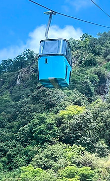
Montetaxco Cable Car – The five minute, four-person cable car took us to the Montetaxco hotel to catch another great view of the city from the hotel’s patio restaurant.

Pre-Hispanic Mine of Taxco (Mina Prehispánica de Taxco) – In 2013, while remodeling the basement bar of a hotel, contractors discovered the remains of an ancient silver mine. It is believed that the Chontal people worked this mine for hundreds of years and later hid it to prevent the Spanish from plundering its riches. The mine is only accessible with an hour-long guided tour. Just be ready to climb lots of steps. For an extra charge you can rappel through the mine’s deepest crevasse.


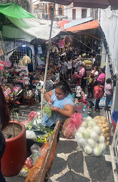
Tetitlán Market (Mercado Tetitlán) – All of the traditional Mexican markets we have visited to date were laid out in a grid like fashion. Because Taxco is so hilly, their public market resembles more a maze with narrow windy alleyways shooting off in all directions. Once inside, it was a challenge finding our way back out. I thought that the place was amazing and could have spent hours exploring, while Sandra thought it was claustrophobic and couldn’t wait to get out.

Puebla
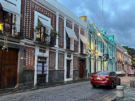
Overview – Puebla was founded by the Spanish in 1531, which is unique for Mexico. Nearly all the other cities in the country were built upon already established pre-Columbian settlements. Thus, Puebla lacks the indigenous cultural roots found elsewhere in Mexico. The original city is also different from typical Mexican colonial settlements in that it was laid out in a grid pattern. Puebla’s historical district consists of 391 blocks and is home to over 2,500 historically significant buildings. These buildings which were built in renaissance and baroque styles are often brightly painted in a vibrant mix of colors, from vivid yellows and oranges to bright reds and blues
Getting There – From CDMX there are numerous express buses a day taking 2.5 hours. The best option for us was to take the single 3.5-hour express bus a day from Taxco.
Getting Around – Puebla does not have any rail transit lines and bus options are limited. Fortunately, almost everything we found worth seeing lies in the city’s central historical district, which is very walkable. For everything else there is Uber and cabify.
Demographics – With a metro population of 3.3MM, Puebla is Mexico’s fourth largest city.
Elevation – 7,000 feet (2,100 meters)

Heading 6

Heading 6

Heading 6


Heading 6


Templo de Santo Domingo – This church which was built in the 1600s is a popular destination for its Rosary Chapel. This chapel is a masterpiece of New-Spanish Baroque architecture and is renowned for its ornate gold-leaf covered walls, ceilings and altars.


Parian Market (Mercado el Parian) – Originally opened in 1760 as a general market, it was converted in 1961 to a traditional handcraft market. It is home to 112 shops displaying handmade pottery, textiles, leather goods, wood pieces and jewelry.


Toad Alley (Callejón de los Sapos) – Toad Alley is a district of antique stores that comes alive on the weekends with street musicians, a large flee market, and food vendors. The district obtained its name from a time when it was flooded with stagnant water prompting an invasion of toads.

Heading 6


House of Culture (Casa de la Cultura) – Built in the 1600s to function as a palace for the bishop, this beautiful tiled colonial building now hosts cultural events, including traditional music and dance shows. This center also has space dedicated to art exhibitions, workshops, film screenings, a bookstore, café, and the Palafoxiana Library (see below).


Palafoxiana Library (Biblioteca Palafoxiana) – Founded in 1646, this is the oldest public library in the western hemisphere. The handsome library houses over 45,000 rare books and manuscripts on its gorgeous hand carved cedar and white pine shelves.


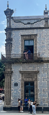
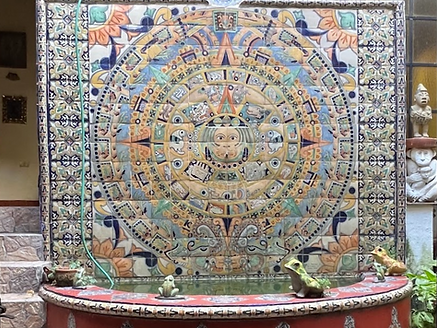
Talavera Ceramics – Talavera is a distinct form of pottery brought to Mexico in the 1500s from Spain that is produced exclusively in the Puebla region. Talavera is used mainly to create household items such as tableware and pots. But it is also used to make decorative figurines and tiles. More than 2,600 of Puebla’s buildings are adorned with these tiles. Talavera ceramics are distinguished by their milky-white tin glaze and hand-painted vibrant designs. Authentic pieces bear a certification and are usually valued at three times the cost of other comparable Mexican ceramic pieces.


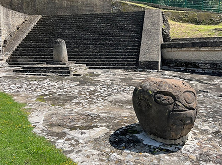
Cholula Archaeological Zone – Standing 216 feet (66 meters) tall and 1,475 feet (450 meters) wide, the Cholula Pyramid is the largest pyramid in the world as measured by volume. However, the bulk of the pyramid has not yet been excavated and looks more like a steep hill. One can only imagine the massive structure that lies beneath. To date only adjacent plazas and courtyards, a portion of the first level of the pyramid, and a network of tunnels that run underneath the structure have been excavated. The tunnels were temporarily closed at the time of our visit. The excavation site has informative signs in English. There is also a small museum with signage only in Spanish. The pyramid is a short walk from Cholula’s central plaza and a half-an-hour Uber ride from Puebla’s historical center.


Heading 6

Sanctuary of the Virgin of Remedies (Santuario de la Virgen de los Remedios) – Sitting on top of the Cholula Pyramid, this church offers spectacular views of Cholula and the Iztaccíhuatl and Popocatépetl volcanoes. Unfortunately, Itzta and Popo (their local nicknames) were hiding the day we were there, so I have included a stock photo of what we missed.


Oaxaca
Overview – Oaxaca is a popular tourist destination. With an abundance of attractive colonial architecture, impressive plazas, vibrant Zapotec culture, colorful markets, and insane street art, Oaxaca has it all. The city is also one of Mexico’s best gastronomic destinations. Here you can enjoy Oaxaca’s unique version of mole, Tlayuda or Tasajo in a scenic rooftop restaurant with one of the nearby mountains that surround the city in the background.
Getting There – There are frequent seven-hour express buses leaving from the TAPO Terminal in CDMX. From Puebla, there are also numerous 4.5-hour express buses to choose from.
Elevation – 5,100 feet
Demographics – Oaxaca has a metro population of 714.000 and is home to around 20,000 Americans.


Heading 6


Heading 6


Heading 6


Street Murals – With over a thousand street murals, Oaxaca is considered one of the best cities in Mexico to view this art form. Oaxaca's street art is rich with traditional themes reflecting its deep cultural heritage.


Heading 6


Heading 6


Oaxaca Ethnobotanical Garden – This 2.3 acres (0.9 hectare) garden features plants from across Oaxaca State, demonstrating the vast biodiversity of this region. Due to previous acts of vandalism, visitors can only see the gardens with a guided tour.


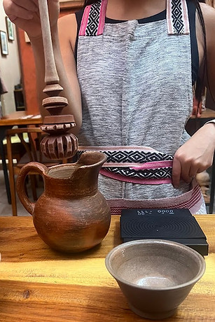
Chocolate Tasting – This city is home to a variety of chocolate shops offering visitors an opportunity to view the production and participate in the tasting of different traditional chocolate products. In this region, pre-Columbian spiritual leaders used cacao as part of their rituals. Chocolate later evolved when the Spaniards introduced sugar to the local diet. Hot chocolate still has deep cultural significance for the natives of Oaxaca and is often served at family gatherings, celebrations, and festivals. Unlike the sweet, watery versions of this beverage, Oaxacan hot chocolate has a distinctly rich, textured, earthy flavor and is always prepared using a molinillo, a traditional wooden whisk that is spun rapidly between the hands.


Monte Albán Archaeological Zone – Sitting on top of an artificially leveled hill in the Oaxaca valley sits the ruins of Monte Albán, the former capital city of the Zapotec people. This city, which was home to an estimated 20,000 people, is one of the oldest cities in the western hemisphere. Monte Albán was inhabited for nearly 1.500 years until it was abandoned in the 800s. The site features a large central plaza surrounded by pyramids, terraces, tombs, and a ball court. The excavation site has informative signs in Spanish and English. There is also a small museum with signage only in Spanish. You can get there by taking a half-hour taxi or an express shuttle departing from the historical center once an hour.

Heading 6


Heading 6

Heading 6


East of Oaxaca Day Trip – There are several interesting tourist destinations just east of the city. The only way to visit all of these sites is by car or guided tour. We opted for an eleven-hour tour.
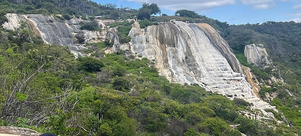
Hierve el Agua – Hierve el Agua (the water boils) is a set of natural travertine white rock formations that resemble two frothy waterfalls. The tallest formation is 98 feet (30 meters). These formations, similar to stalactites in caves, have been created over thousands of years from a spring saturated with calcium carbonate and other minerals slowly tricking over a cliff. There are only two other similar formations like this in the world. At the top of the “falls” are two large artificial pools and a couple of smaller natural pools. The formation’s name is misleading because the water in these pools is cool. But it is still a great place to relax and enjoy the panoramic views after a sweaty hike to the bottom of the “falls” and back. The formation is not accessible by public transit and is a two-hour drive from Oaxaca.


Heading 6


Mitla Archaeological Zone – Mitla is a small but important Zapotec archaeological site. The buildings on the site were used as the homes and workspaces for the high priests to perform their rituals. Milta is renowned for its stunning geometric stone mosaic decorations that are thought to symbolize aspects of nature such as wind, water, sky and earth. Each piece of stone was cut to fit a pattern, then set in mortar on the walls and painted. Mitla is a 1.5-hour bus plus taxi ride from Oaxaca.


Heading 6


Teotitlán del Valle – Teotitlán del Valle is a small village known for its colorful rugs woven on hand-operated looms, with wool from local sheep and dyed using local natural materials. These artists combine historical Zapotec designs with contemporary imagery to create beautiful pieces of art. We were brought to one of the village’s many workshops for a tour of the process. We were shown how grinding dried cochineal insects with water and lime juice creates a vivid red, and then by adding baking soda to this mixture changes it to a vivid purple.


Mezcal Distillery Tour & Tasting – Mezcal is a popular alcoholic drink produced from the agave plant, a large succulent that only grows only in arid regions. Over forty different varieties of agave are used to produce unique tasting mezcal, ranging from fruity and floral to earthy and smoky. Bottles can only be labeled as Mezcal if they come from one of nine states, of which Oaxaca is by far the biggest producer. To create Mezcal choice parts of the agave are roasted in a pit, then pressed to release a runoff juice, which is fermented, and then finally distilled. After the tour we were all given a shot glass of thirteen different mezcals to sample. This was a perfect way to end our Mexican adventure.


Heading 6

